
Arctic Blast Grips US Record Cold Slams Midwest And Northeast
The Arctic Blast grips the US once again as a powerful surge of polar air pushes deep into the Midwest and Northeast, sending temperatures to dangerous lows and triggering widespread weather alerts. This sudden US cold snap has brought sub-freezing conditions, icy roads, heavy snow in some regions, and wind chills cold enough to cause frostbite in minutes. As residents face one of the most severe early-winter outbreaks in years, the nation is dealing with record-breaking cold temperatures in the Midwest and rapidly worsening conditions in the Northeast.
What is an Arctic blast?
An Arctic blast happens when a rush of extremely cold, dense air moves down from the Arctic or polar regions. This usually occurs when the jet stream shifts, letting frigid, high-pressure air travel south into areas like the United States. As a result, temperatures plummet suddenly, often with strong, gusty winds that can make it feel even colder due to wind chill. These blasts bring harsh winter conditions and severe cold to the areas they affect.
What’s Causing This Arctic Blast Grip in the US
A massive Arctic air mass slipped south from Canada due to a disruption in the polar air pattern. When the upper-level winds weaken, polar air escapes into lower latitudes—and that’s exactly what unfolded this week.
Meteorologists explain that a sharp atmospheric dip allowed Arctic winds to funnel straight into the central and eastern United States, creating a deep freeze that settled across multiple states.
This pattern is typical during intense winter outbreaks, but what made this event stand out is how quickly temperatures fell and how far the cold air travelled. Cities that normally sit above freezing during early December dropped to levels more typical of mid-January.
In short: the polar vortex has shifted, the jet stream is wavy, and cold Arctic air is being funnelled deep into the U.S.—a classic setup for major winter disruption.
Midwest Freezes Under Record Cold
The Midwest experienced the most dramatic drop as the Arctic Blast swept across the region overnight. Many states reported temperatures 15–25°F below normal, with some locations breaking long-standing records.
Record Lows Set Across the Region
- A town in Iowa dropped to –19°F, marking one of its coldest temperatures ever recorded this early in the season.
- Wind chills in northern Minnesota, the Dakotas, and parts of Wisconsin dropped to well below –30°F.
- Several communities around the Great Lakes faced sudden lake-effect snow as frigid air moved over warmer waters.
Residents woke up to frozen roads, icy windshields, and frigid gusts, making outdoor activities nearly impossible. Emergency services also reported an uptick in cold-related calls as the weather deteriorated through the morning.
This wasn’t just another winter day—it became a record cold event for the Midwest and showed just how intense early-season Arctic outbreaks can be.
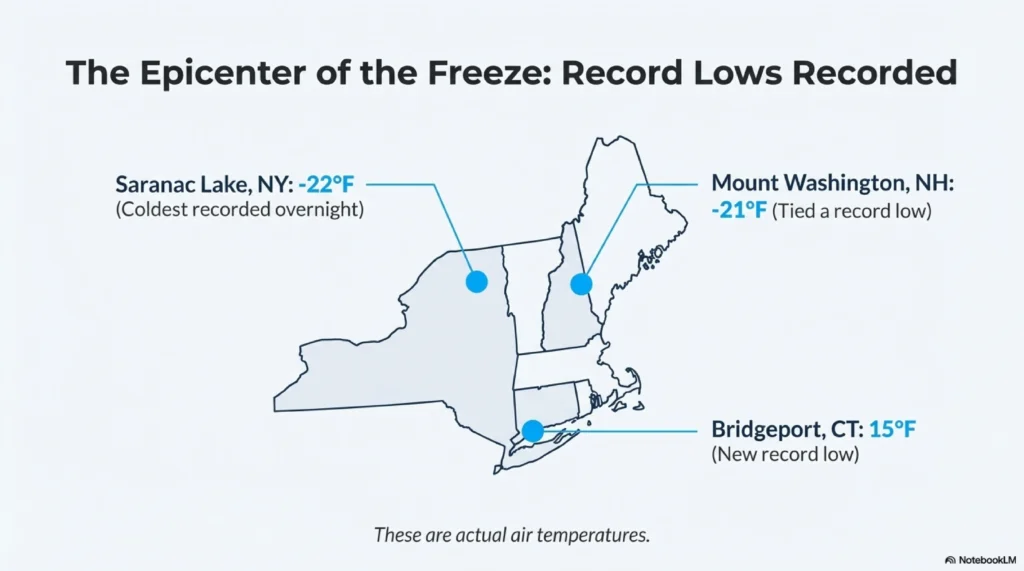
Northeast Braces for Dangerous Cold Weather
So far, the Midwest and Plains have taken the brunt of the cold. Cities across Iowa, Illinois, Minnesota, and surrounding states have recorded record-breaking sub‑zero temperatures. For example, in some Iowa communities—such as Estherville, Mason City, and Waterloo—temperatures dropped to as low as –26.1 °C (about –15 °F), smashing previous low-temperature records.
Cities Affected
The cold blast isn’t limited to the central U.S. It’s sweeping east—reaching the Northeast and Mid‑Atlantic states. Cities from New York and Pennsylvania to New England are seeing brutal lows and wind chills.
Snow and Ice Threat Increasing
Alongside the freeze, many Northeast and Mid-Atlantic cities faced:
- Freezing rain
- Black ice
- Visibility-reducing snow bands
- Disrupted flights at major airports
This combination created widespread current US weather warnings across multiple states.
Frostbite Warnings Issued
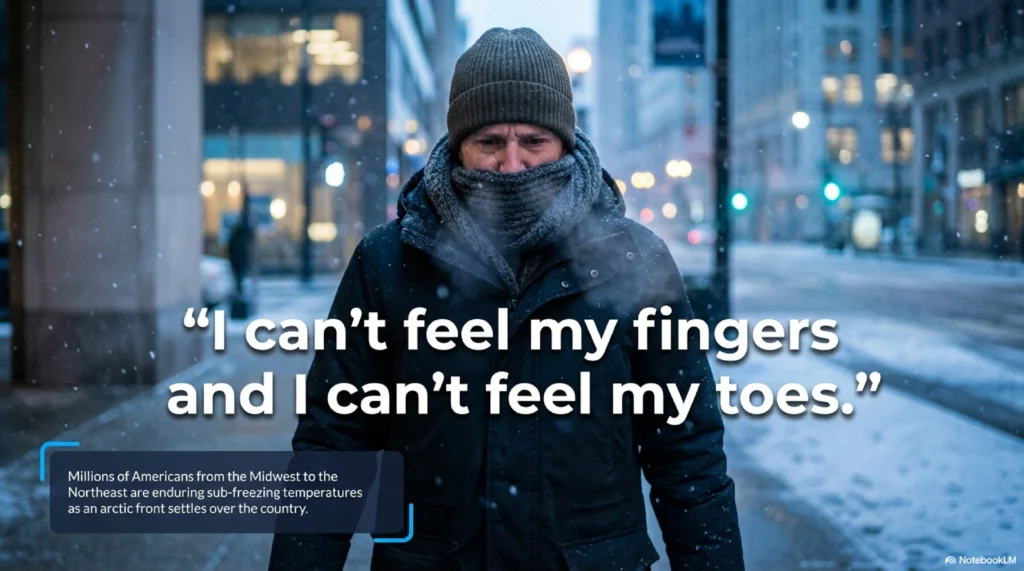
The most immediate and dangerous threat from this arctic blast is the risk to human health, specifically frostbite and hypothermia. The National Weather Service has issued wind chill warnings across the affected regions, emphasizing that exposure to these extreme conditions can cause significant harm in minutes.
Frostbite is an injury that occurs when skin and underlying tissue freeze. The risk is determined by a combination of actual air temperature and wind speed (the wind chill factor), which dramatically increases the rate at which the body loses heat.
Speed of Onset: In many areas experiencing wind chills near -20° Fahrenheit, frostbite can affect exposed skin in as little as 30 minutes. Where wind chills drop to -30°F or lower, exposed skin can freeze in just 10 to 15 minutes or less.
Warning Signs: Affected skin may appear whitish, pale, or waxy, and feel numb rather than painful, which makes it particularly insidious.
Prevention: Health experts urge residents to limit time outdoors, cover all exposed skin (fingers, toes, ears, nose) with warm, layered, windproof clothing, and seek medical attention immediately if symptoms are detected.
How Long Will the Cold Last?
Meteorologists say that the current Arctic air mass will linger over the Midwest and Northeast for several days. Nighttime temperatures are expected to remain far below freezing, with wind chills making it feel even colder. Some regions could experience repeated waves of cold as the Arctic high-pressure system shifts slowly, keeping the frigid conditions in place. This means residents should prepare for multiple mornings of icy roads and dangerous outdoor exposure.
As the week progresses, slight fluctuations may occur, but a rapid warm-up is unlikely. Snowfall and freezing rain could continue in moisture-rich areas, particularly near the Great Lakes and Northeast. Winter travel disruptions, flight delays, and school closures are still possible as roads remain hazardous. These persistent conditions show how powerful and long-lasting a U.S. Arctic blast can be when polar air pushes deep into the country.
Speed of Onset: In regions with wind chills near –20°F, exposed skin can develop frostbite in as little as 30 minutes. Where wind chills fall to –30°F or lower, exposed skin can freeze in just 10 to 15 minutes—or even faster.
Warning Sign: Affected skin may appear whitish, pale, or waxy and feel numb rather than painful, which makes it particularly insidious.
Prevention: Health experts urge residents to limit time outdoors, cover all exposed skin—fingers, toes, ears, and nose—with warm, layered, windproof clothing, and seek medical attention immediately if any symptoms appear.
Impact on Daily Life and Travel
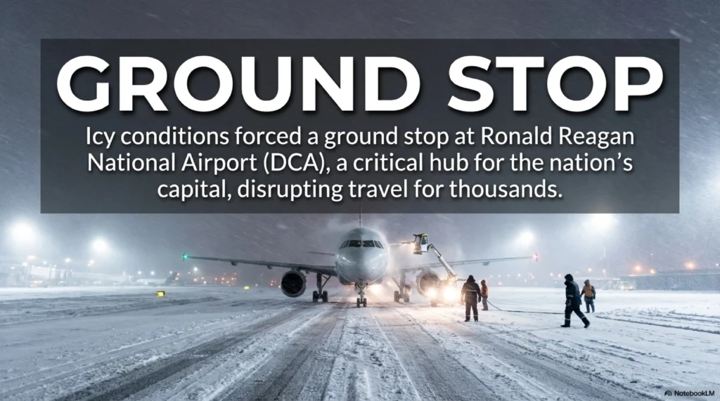
Travel Delays and Flight Cancellations
The Arctic blast has caused major disruptions at airports across the Midwest and Northeast. Freezing fog and icy runways led to flight delays and cancellations. Ground crews are struggling to de-ice planes as temperatures remain dangerously low. Travellers are advised to check flight status frequently and allow extra time for airport procedures.
Road Hazards
Black ice is forming rapidly on highways, making driving extremely hazardous. Several accidents have already been reported due to sudden slippery conditions. Commuters are urged to slow down and drive cautiously. Emergency services are responding to increased traffic incidents caused by the extreme cold.
School Closures
Many school districts in affected states have delayed openings or cancelled classes entirely. The decision is based on both road safety and sub-zero wind chills. Parents are advised to monitor local announcements for updates. Children and staff should take precautions if venturing outdoors during brief periods.
Power Demand Surge
The record cold has driven up heating demand in homes and businesses. Utility companies warn that local power grids could face strain during peak hours. Residents should use energy wisely and have backup heating options ready. Staying alert can help prevent outages and keep homes safe.
Climate Context: Why Is This Happening?
While cold snaps are a normal part of winter, scientists note that changes in the Arctic are making extreme outbreaks more frequent. Warming in the Arctic weakens the jet stream, allowing it to meander southward. This creates a pathway for polar air to plunge into the Midwest and Northeast, resulting in record-breaking cold conditions. Such disruptions explain why the Arctic Blast in the US has been so intense this season.
These shifts don’t mean winters are getting colder overall. Instead, the polar vortex’s waviness causes larger swings between warm and cold periods. Combined with moisture from the Great Lakes and Atlantic, this can produce snow, freezing rain, and icy roads. Understanding these patterns helps explain the persistent Northeast cold weather and extreme lows in the Midwest record-cold regions.
How to Stay Safe During Extreme Cold
1. Dress in Layers
Wear multiple layers of insulation, including a warm jacket, gloves, a hat, and waterproof boots. Layering helps trap heat and protects against frostbite. Even short outdoor exposure can be dangerous in extreme wind chills.
2. Limit Outdoor Exposure
Avoid spending long periods outside during the coldest parts of the day. Keep outdoor activities to a minimum, especially in areas under frostbite warning in Northeast conditions. Monitor weather updates to stay informed about sudden temperature drops.
3. Prepare Your Home
Seal drafts, maintain your heating system, and use space heaters safely to prevent indoor hazards. Protect pipes from freezing and keep emergency supplies on hand. Check on vulnerable neighbours, pets, and family members to make sure everyone stays safe.
The Arctic Blast grips the US with an intensity that has shattered records, disrupted travel, and placed millions under severe cold warnings. As record-breaking cold temperatures in the Midwest and worsening wind chills in the Northeast continue, communities must stay alert and prepared. Early winter has arrived with full force, reminding everyone how quickly conditions can shift when Arctic air dives south.
Staying informed and following safety measures will help reduce risks as temperatures remain dangerously low. While the cold snap may ease gradually, the next few days remain critical—and being prepared is the best defence in this powerful winter event.
Read more related articles> https://www.climatechallange.com/hows-u-s-winter-weather-changing-in-a-warming-world/
FAQs
Q1. Is the polar vortex coming during this Arctic blast?
Ans. The polar vortex itself stays in the upper atmosphere, but disturbances in its circulation allowed Arctic air to escape southward. This shift is why the Arctic Blast gripped us, and temperatures fell so sharply. When the vortex weakens, extreme cold events become more likely across central and eastern states.
Q2. Where is the Arctic air mass now in the US?
Ans. The core of the Arctic air mass is currently centered over the Midwest and Northeast, producing widespread US cold snap conditions. Temperatures in these regions are the lowest, with wind chills far below zero and additional cold waves expected as the week continues.
Q3. How do Arctic blasts work?
Ans. An Arctic blast occurs when a large mass of frigid, dense air from the Arctic rapidly moves south into mid-latitude regions like the United States. This surge occurs when the jet stream weakens and dips into North America, allowing the frigid air a path to escape its usual polar boundary. When it pushes in, temperatures drop sharply, wind chills become intense, and widespread winter weather hits the affected areas.