Nepal Floods 2026: Could This Happen Again In The Himalayas
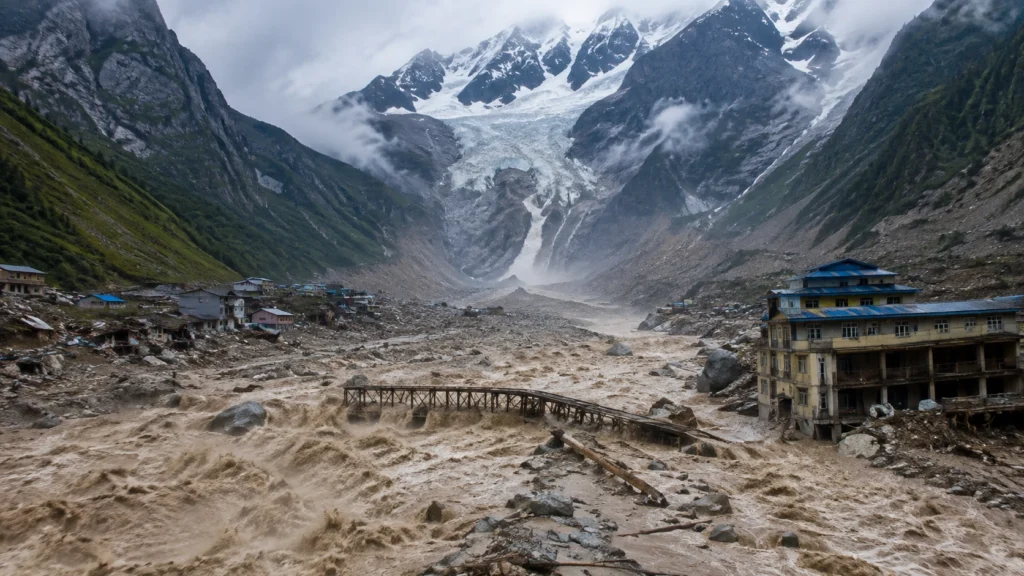
The Nepal Floods 2026 disaster was not a typical monsoon flood. On August 26, a massive collapse in the high Himalayas sent ice, rock, water, and debris rushing into river valleys near the Nepal Tibet border. The flood traveled for nearly 100 kilometers, destroying roads, bridges, buildings, and other infrastructure along the way.
But the bigger question now is not only what caused the disaster. Could something similar happen again in the Himalayas? The answer is complicated, but scientists and authorities are already watching for signs of further flooding, unstable slopes, and dangerous glacial lakes.
How Did the Disaster Begin?
The disaster began on August 26 in Nepal’s Rasuwa area, near the border with China. A rapid collapse involving a glacier and mountain debris produced a powerful flow that entered the river system and moved downstream with enormous force.
The event affected the Bhote Koshi and Trishuli river corridors and also reached the Gyirong area on the Chinese side of the border. According to the U.S. Geological Survey, the debris flow and flood traveled approximately 100 kilometers, while seismic analysis indicated that the initial collapse released energy equivalent to a magnitude 5.2 earthquake.
This helps explain why the Nepal flash floods were so destructive. It was not simply water rising gradually after heavy rainfall. A huge amount of ice, rock, sediment, and water moved through narrow mountain valleys, turning the flood into a fast moving debris flow.
Areas Affected by the Flooding
The worst damage has been reported in northern Nepal, especially around Rasuwa and Nuwakot districts near the Nepal Tibet border. The debris flow has pushed the death toll above 630, with nearly 3,000 people still missing, while the Bhote Koshi and Trishuli river systems have suffered major damage to key infrastructure, including the Rasuwagadhi and Trishuli hydropower plants.
The location makes the impact worse because Himalayan valleys can funnel huge amounts of water and debris through narrow channels, allowing the flow to travel far downstream.
That is why the Nepal Tibet floods have become a wider regional concern. Rebuilding damaged cross border trade routes, roads, and power infrastructure could cost as much as $5 billion.
Why the Flood Caused So Much Damage
The Nepal flood cause was a chain of events rather than one simple factor. USGS analysis points to a glacial collapse that sent ice and debris downslope. The material contained water and ice, and as it moved through the landscape, it picked up additional rock and water.
That combination created a dense, destructive flow capable of carrying huge boulders and other debris. Instead of behaving like ordinary floodwater, it acted more like a rapidly moving mixture of mud, rocks, ice, and water.
This distinction is important because it also explains why standard rainfall based flood expectations may not fully capture this type of hazard.
Ongoing Flood Risk in the Region
After the initial disaster, authorities had to monitor a lake and unstable debris in the affected mountain area. A natural barrier can temporarily hold back water, but if that barrier weakens or breaks, it can release a sudden surge downstream.
That does not mean another major flood is certain. Later monitoring showed that the immediate risk from one lake was easing, but the situation still highlights how flood threat can continue after the first wave has passed.
Nepal’s Department of Hydrology and Meteorology continues to monitor river conditions and issue flood warnings. Its system also provides real time hydrological information and early warning services.
Rising Risks in Himalayan Glacier Areas
Glaciers are not dangerous simply because they exist. The concern comes from warming temperatures, changing ice conditions, unstable mountain slopes, and the growth of glacial lakes.
As the Himalayas warm, glaciers and frozen ground are changing. These conditions can increase the risk of landslides, ice rock avalanches, and glacial lake outburst floods, commonly known as GLOFs. Scientists are therefore monitoring high-altitude lakes and glacier changes, especially in the China Nepal Himalayas, which face significant GLOF risks.
However, climate change cannot be blamed for every part of the August 26 disaster. The event resulted from a complex interaction between glaciers, unstable slopes, rivers, and mountain geology, although climate change may influence the conditions that make such hazards more likely.
The Risk Across the Himalayas
The bigger concern is not limited to Nepal.
The Himalayas stretch across several countries, including Nepal, China, India, Bhutan, and Pakistan. Many communities live below steep mountain slopes, glaciers, and glacial lakes. A sudden collapse at high elevation can therefore create risks far from the original source.
That does not mean every Himalayan valley faces the same level of danger. Local geology, lake size, drainage routes, slope stability, settlement patterns, and warning systems all make a difference. Still, the Nepal disaster shows how quickly a high altitude event can become a regional emergency.
Final Thoughts
The Nepal Floods 2026 show how quickly a high altitude disaster can affect communities far beyond its starting point. While another event cannot be predicted with certainty, changing glaciers and unstable mountain conditions make preparedness more important than ever. Climate resilience is no longer just an option for Himalayan communities; it is becoming a necessity. Better monitoring, early warnings, and stronger infrastructure can help reduce the damage when the next major event occurs.
FAQS
Q1. Can These Floods Be Predicted?
Ans. Scientists can monitor glaciers, glacial lakes, rainfall, river levels, and ground movement, but predicting an exact glacier collapse remains difficult. Satellite monitoring and early warning systems can still give communities valuable time to evacuate.
Q2. What About the Nepal Monsoon?
Ans. Nepal’s 2026 monsoon was forecast to bring below average rainfall across much of the country. That matters because the August 26 disaster was linked mainly to a sudden glacial and debris collapse rather than a typical rain fed flood. This proves that high altitude hazards, like ice rock avalanches, can trigger massive disasters independently of heavy seasonal rainfall.
Q3. What Is the Current Situation in Nepal?
Ans. Rescue and recovery efforts are still underway across the affected regions. Northern Nepal has suffered severe infrastructure damage, with the death toll crossing 630 and nearly 3,000 people still reported missing. Authorities also continue to closely monitor potential secondary flood risks in the area.
Q4. What caused the Nepal Floods 2026?
Ans. The disaster was caused by a massive glacial and ice-rock collapse near the Nepal-China border, not by regular monsoon rains.
Q5. Which countries face this Himalayan flood risk?
Ans. Entire Himalayan region across Nepal, China, India, Bhutan, and Pakistan faces serious risks due to warming temperatures and unstable glacial lakes.